Satellite Constellation Avoidance with the Rubin Observatory Legacy Survey of Space and Time
Abstract
We investigate a novel satellite avoidance strategy to mitigate the impact of large commercial satellite constellations in low-Earth orbit on the Vera C. Rubin Observatory Legacy Survey of Space and Time (LSST). We simulate the orbits of currently planned Starlink and OneWeb constellations (40,000 satellites) to test how effectively an upgraded Rubin scheduler algorithm can avoid them, and assess how the overall survey is affected. Given a reasonably accurate satellite orbit forecast, we find it is possible to adjust the scheduler algorithm to effectively avoid some satellites. Overall, sacrificing 10% of LSST observing time to avoid satellites reduces the fraction of LSST visits with streaks by a factor of two. Whether such a mitigation will be required depends on the overall impact of streaks on science, which is not yet well quantified. This is due to a lack of adequate information about satellite brightness distributions as well as the impact of glints and low surface brightness residuals on alert purity and systematic errors in cosmological parameter estimation. A significant increase in the number of satellites or their brightness during Rubin Operations may make implementing this satellite avoidance strategy worthwhile.
1 Introduction
Rubin Observatory’s Legacy Survey of Space and Time (LSST) is a ten-year astronomical imaging survey that will begin in 2024 from a new telescope under construction in Chile. Instead of soliciting individual requests for what the telescope should observe, the LSST will uniformly survey the sky every few nights using six color filters to create a decade-long high-resolution survey of the entire southern sky, and share massive quantities of data products with the astronomy community (Ivezić et al., 2019). To accomplish this, the LSST will employ a scheduling algorithm that uses a modified Markov Decision Process which can generate lists of desirable observations in real time (Naghib et al., 2019). The LSST scheduler balances the desire to minimize slew time, optimize signal to noise in individual images, and to maintain survey footprint uniformity.
One challenge for the LSST is that increasing numbers of bright low-Earth orbit (LEO) satellites (e.g., Starlink) are being launched, which may leave streaks in astronomical pointings. LEO satellites are visible from Earth because they reflect sunlight, especially during twilight. As the Sun-illuminated satellites move across the field of view of an astronomical pointing, they leave a streak in the image. While the flux from satellite streaks can in many cases be identified and removed, the resulting pixels have much lower signal-to-noise. For a thorough discussion of the scientific utility of residual light after masking satellite trails, see Hasan et al. (2022). Over the last three years, many astronomers have raised concerns about the impact of the proliferation of commercial satellites on the LEO ecosystem and astronomical surveys (Lawrence et al., 2022; Tyson et al., 2020). In addition, astronomers have come together with satellite operators and other stakeholders to create recommendations and strategies to mitigate impacts to observational astronomy and beyond (Walker et al., 2020a; Hall et al., 2021; Walker et al., 2020b, 2021).
Tyson et al. (2020) used a very simple algorithm to see if the LSST could avoid imaging satellite streaks. They concluded that attempting to naively dodge of order 48,000 LEO satellites is useless because it is operationally inefficient. In this paper, rather than try to avoid all satellite streaks, we incorporate satellite avoidance as a component of the LSST scheduler’s Markov Decision Process. This allows us to avoid a significant fraction of satellite streaks and investigate what level of avoidance might be acceptable because it does not drastically impact the overall performance of the LSST.
There are other efforts underway to mitigate the impact of satellite streaks in astronomical images. For example, satellite companies like SpaceX have worked on darkening the exterior of satellites so they will be less visible111https://api.starlink.com/public-files/BrightnessMitigationBestPracticesSatelliteOperators.pdf. However, even with the most effective darkening mitigations to date, satellites still appear bright to the LSST Camera, and are likely to cause effects like non-linear crosstalk or glints that are challenging to correct with the LSST Science Pipelines software and may introduce systematic biases or spurious detections. This is discussed in more detail in Tyson et al. (2020) and on the Rubin Observatory LSST Project website222https://ls.st/satcon. Astronomers have also developed algorithms for masking satellite trails in images, but covering the outer wings of the trails without losing extra pixels remains a challenge (Hasan et al., 2022). The rapid increase in population of LEO satellites threatens to compromise the quality and scientific value of LSST images and also requires extra human and computer resources to effectively mask trails. Thus, we explore an additional option: incorporating the orbits of known commercial satellites into the LSST scheduler so the worst of them may be avoided.
In this paper, we first create realistic simulated forecasts of satellite orbits in Section 2. We then build a tool that uses that data to create new scheduler constraints, and test the impact of the modified scheduler algorithm on LSST observing programs in Section 3. Finally, we discuss the resulting trade-off between number of streaks and reduced survey depth that results from avoiding satellites in Section 4, and lay out possibilities for the future as the satellite population changes during Rubin Operations. We also make available a GitHub repository with the data and software necessary to reproduce the paper’s figures333https://github.com/lsst-sims/satellite-dodging-ApJL.
2 Methods
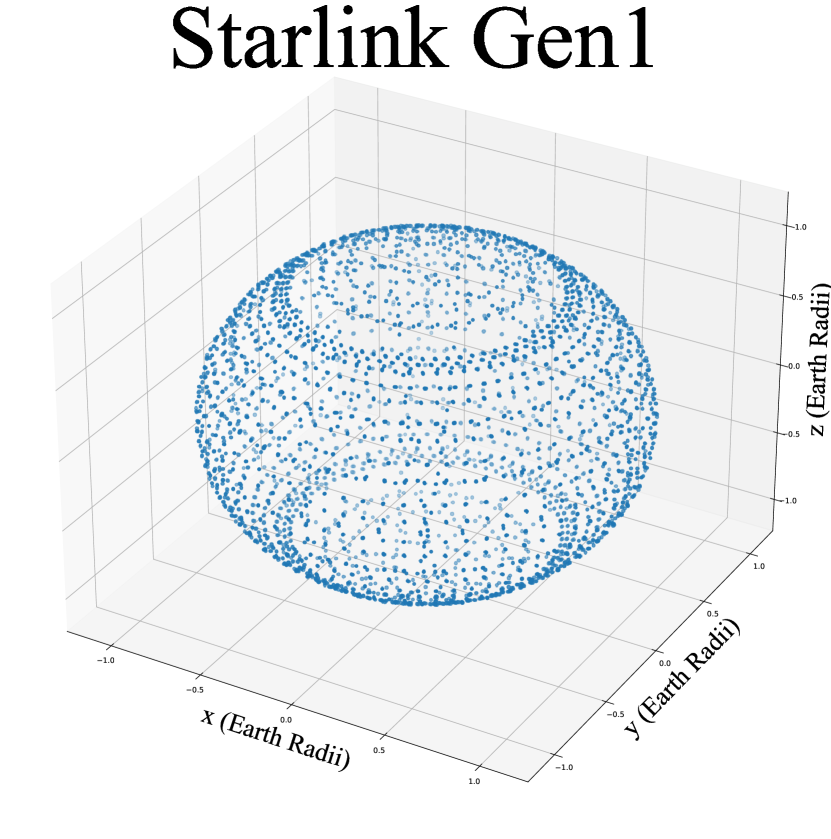
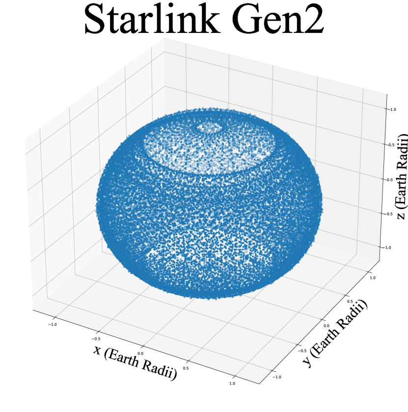
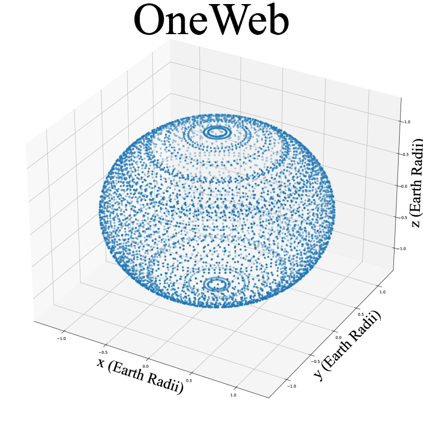
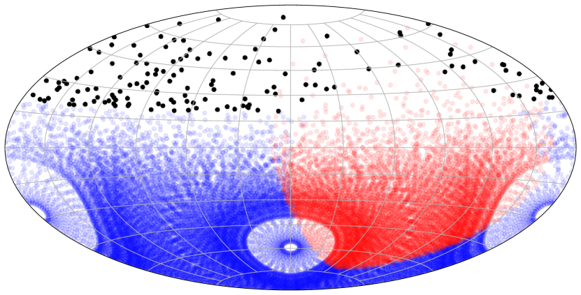
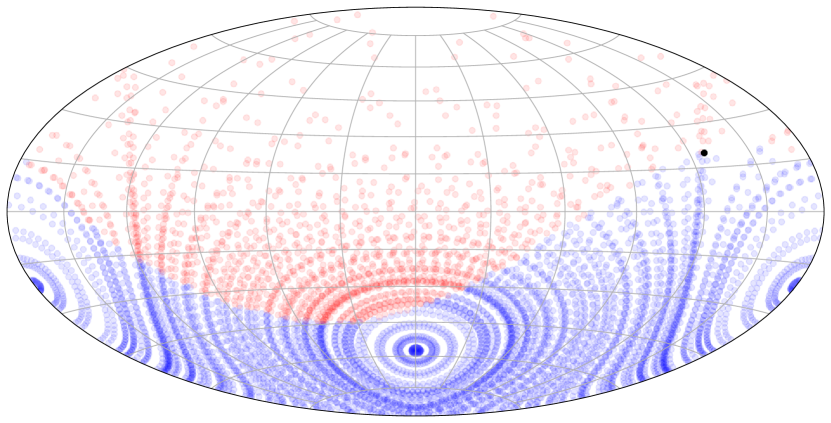
We begin by creating realistic forecasts of three commercial satellite constellations, which are illustrated in Figure 1. These are Starlink Gen1 (4,408 satellites, altitude km), OneWeb (6,372 satellites, altitude 1200 km), and Starlink Gen2 (29,988 satellites, altitude km). Each constellation uses orbital inclinations and number of satellite planes matching current plans444https://ls.st/x1o. To date, OneWeb has launched and deployed several hundred satellites, while the number of Starlink satellites is in the thousands.
To simulate LSST observations, we start with the baseline observing strategy in Yoachim et al. (2022a). LSST observations are scheduled in visits, where a visit is one 30s exposure and visits in all other filters () are back-to-back 15s exposures. The baseline strategy attempts to take most observations in mixed filter pairs (e.g., an visit followed by an visit 33 minutes later), and completes 215,000 visits in the first year.
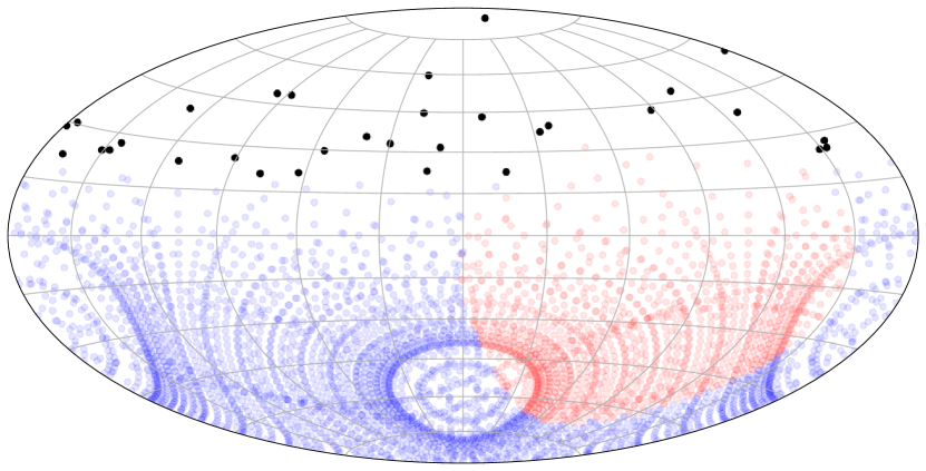
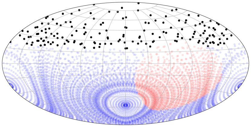
The baseline LSST observing strategy uses three primary basis functions which reward (1) minimizing slewtime, (2) maximizing the depth of images (e.g., by avoiding the Moon and high airmass), and (3) maintaining a uniform survey footprint. To this, we add a fourth basis function which penalizes observing areas of the sky which will have high concentrations of illuminated satellites. Figure 2 shows an example of this new basis function for the three simulated satellite constellations. The positions of the illuminated satellites are computed in 10-second intervals and marked on the sky. These maps are then summed over 90-minute blocks to generate the basis function maps. Thus our modified scheduler with a satellite avoidance strategy does not try to avoid individual satellite streaks, but rather has a parameterized method for avoiding regions of the sky where satellite streaks are more likely. This has the additional benefit of not requiring high precision satellite orbit forecasts.
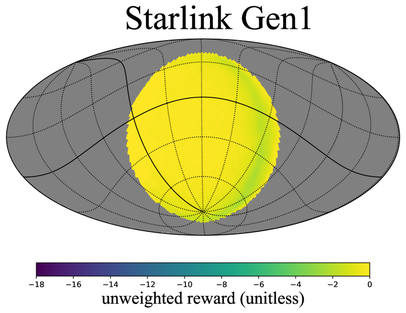
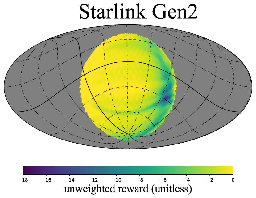
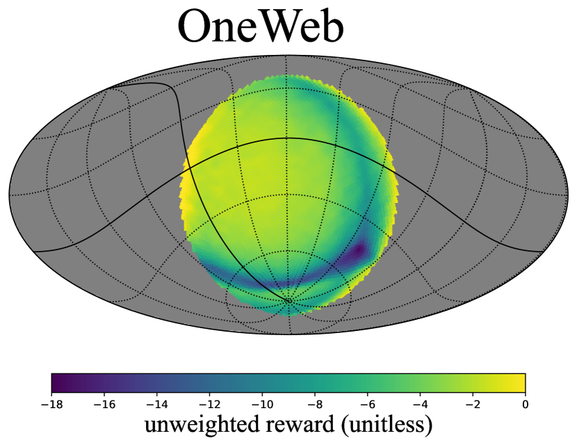
We show three example satellite avoidance maps ready for use by the LSST scheduler in Figure 2. It is apparent from Figure 2 that the simulated OneWeb constellation has more negative area — regions that should be avoided due to large numbers of illuminated satellites — than the other two constellations. Although OneWeb has fewer satellites than Starlink Gen2, the OneWeb satellites orbit at a higher altitude (1200 km compared to 340-614 km for Starlink), meaning that they will be illuminated for a longer portion of the night, and also have a larger impact close to twilight. This is why one of the recommendations from Walker et al. (2020a) is to keep LEO satellites below 600 km altitude.
To investigate whether the scheduler behaves how we expect with the new satellite avoidance strategy, we create a testing function that measures the length of satellite streaks in the simulated fields of view. To ensure efficiency, only satellites that are above the altitude limit and illuminated by the Sun are considered. Satellites below the altitude limit (indicated in the gray region in Figure 2) cannot be reached by the Simonyi Survey Telescope and are therefore not included. For each satellite, we first determine whether it is in the field of view for a given pointing by calculating their distance from the center of the field of view. If this distance is less than the radius of the field of view, the satellite has crossed through the pointing. To quantify the impact of the satellite on the pointing, we then project both the satellite location and the pointing to a 2D x,y plane. In this plane, the field of view is roughly circular and the start and end locations of the satellite crossing are two points on the plane, and we can calculate the total intersection length. Therefore, given a simulated satellite constellation and a schedule of observations, we are able to record the number of satellites in each pointing and measure the total streak length. We assume that the impact of streaks on science is proportional to their total length, which allows us to quantify the efficiency of the satellite avoidance strategy.
To estimate the fraction of pixels affected by streaks, following Hasan et al. (2022) we adopt a fiducial width of 300 pixels (equivalent to 1 arcminute given the plate scale of 0.2 arcseconds per pixel). The 3.5 degree diameter Rubin focal plane is populated with 189 4kx4k CCDs. Assuming a length of 15 CCDs (with a CCD side of 4096 pixels), a single streak corresponds to 0.6% of all the pixels in the focal plane. On the other hand, if a streak is so bright that entire CCDs are rendered scientifically useless, a single streak would wipe out 8% of all pixels in the focal plane.
We simulate observations for only the first year of the planned ten-year LSST, as the survey strategy does not significantly change in later years. We acknowledge this does not account for the likely satellite population increase beyond the three simulated constellations; however, our results should scale linearly to larger future constellations in similar orbital distributions. We do not consider the effects of satellites launching or de-orbiting, and for simplicity we assume each satellite’s orbital parameters are constant. This should be an acceptable approximation as long as actual satellite orbital parameters are available day in advance so our avoidance basis functions can be constructed. If there is no timely information publicly available on LEO satellite constellation orbits, or it is highly inaccurate, the satellite avoidance strategy would be impossible to implement. We estimate that satellite orbital solutions correct to within about a degree in space and to within a few minutes in time would be sufficient to effectively avoid some regions of the sky with more satellites in large constellations. Observing current Starlink satellites, Halferty et al. (2022) find they can construct TLEs which predict positions with sub-degree spatial precision and sub-second temporal precision which is more than adequate for our proposed satellite avoidance methods.
3 Results
We find that higher dodging weights reduces pixels lost to satellite streaks, and that the satellite avoidance algorithm is able to effectively avoid satellite streaks in simulated pointings. This is shown in the top two panels of Figure 3. We also find that smaller constellations at lower orbital altitudes (Starlink Gen1, for example) inherently cause less pixel loss per pointing, nearly independent of the dodging weight.

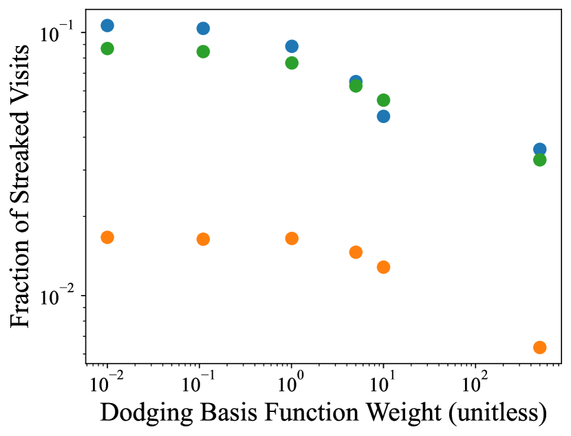


Next, we investigate the relationship between the number of exposures the scheduler is able to complete as a function of the dodging weight. As shown in the bottom two panels of Figure 3, higher dodging weight results in fewer visits, most likely due to longer slew times. With a higher dodging weight, the telescope may be prompted to slew to a location other than the most desirable nearby pointings, resulting in fewer overall exposures. We also find that a larger constellation (Starlink Gen2) tends to decrease the number of exposures slightly more than a smaller constellation (Starlink Gen1), which is expected. More satellites or satellites at higher orbital altitudes result in larger areas of avoidance on the sky, which leads to more slewing required to avoid the affected areas, which subsequently reduces the total number of visits. In addition to forcing longer slews, avoiding satellite dense areas pushes the scheduler to observe pointings with lower signal to noise (e.g., higher airmass, brighter sky background areas) than it normally would.
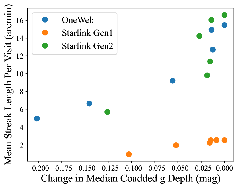
One important LSST survey goal is to collect a large number of exposures of the whole southern sky so these may be co-added to reveal faint structures that are not visible in individual visits. As a result, survey depth is crucial to LSST science, and the trade-off between pixel loss from satellite streaks versus survey depth reduction from fewer total visits must be evaluated. With the satellite avoidance algorithm, the scheduler is prompted to avoid regions with illuminated satellites, which sometimes results in longer slew times or less desirable pointing conditions and contributes to a loss in survey depth. Therefore, Figure 4 explores the trade-off between survey depth loss and satellite avoidance. As evident from the figure, the fraction of LSST visits with streaks can be decreased by a factor of two with an investment of 10% of LSST observing time, corresponding to a loss of coadded depth of 0.05 mag.
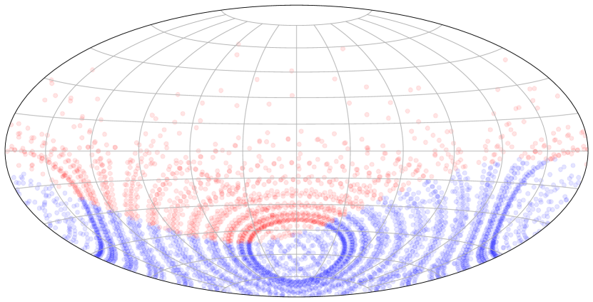
So far, we have primarily considered impacts on the overall LSST. However, another important LSST science goal involves using twilight images to search for Near Earth Objects (NEOs) and solar system objects interior to the orbits of Earth and Venus. These observations must be taken in the direction of the rising or setting sun at high airmass. Because a small potential area is targeted, our proposed satellite avoidance scheme is ineffective. Figure 5 shows how regular survey observations and twilight NEO observations would be affected by satellite constellations using the LSST scheduler with no satellite avoidance. While the majority of twilight NEO observations could include a satellite streak with a Starlink Gen2 size constellation, we find this would only result in a 0.36% loss of science pixels (for a 1 arcminute wide mask).


4 Discussion
We have demonstrated that adding a weighted term in the scheduler algorithm for illuminated satellites can effectively reduce the amount of satellite streaks in observations, and subsequently reduce mean pixel loss per visit and other impacts on science, as illustrated in Figure 3. However, with the new added priority on satellite avoidance, the telescope can be pushed to take an observation path that does not optimize slew time, which subsequently reduces the number of exposures and overall survey depth. The trade-off essentially comes down to the relationship between total streak length reduction and survey depth reduction. The final decision will depend on the overall impact of streaks on science which is not well quantified yet due to a lack of adequate information about the satellite brightness distribution and the impact of glints and low surface brightness residuals on alert purity and systematic errors in cosmological parameter estimation. In other words, when evaluating whether to implement a weighted satellite avoidance strategy to effectively reduce satellite streak density, it is necessary to evaluate the trade-off between pixel loss together with non-linear crosstalk, time-domain glint effects, and any other relevant systematics versus loss in observing time.
We note that earlier publications (Lawrence et al., 2022; Tyson et al., 2020) stated that the majority of LSST images are likely to contain a satellite streak. They also included some higher-altitude Starlink orbits that are no longer planned. Our study finds that about 10% of all LSST images will have a streak from the three simulated constellations (Starlink Gen1, Starlink Gen2, and OneWeb, totaling 40,768 satellites as currently planned). It is true, however, that twilight observing campaigns at high airmass — like those necessary to perform NEO searches — will have streaks in the majority of images.
There is a concerning possibility of sharp increases in satellite population in the next years, overlapping the LSST operations period (). With a dramatic increase in satellite population, the ability to avoid satellites might become more relevant. It is possible to linearly extrapolate our results to consider a possible LEO satellite population in the hundreds of thousands circa 2030, assuming the orbital distribution in LEO is similar to that of Starlink and OneWeb. A future with 400,000 LEO satellites rather than 40,000 — the stated goal of various companies intending to launch very large constellations given the present filings555https://planet4589.org/space/stats/conlist.html — could render the trade-off of 10% of LSST observing time in order to cut the number of visits with streaks in half worthwhile. Tyson et al. (2020) find that satellites with AB magnitudes of to would saturate LSST images. Satellite streaks from Starlink and OneWeb as presently designed are not expected to saturate the LSST Camera’s CCD detectors as they have magnitudes of in their final orbits (Halferty et al., 2022). While a star of would be very saturated in a LSST images, LEO satellites are moving fast enough that their effective exposure time is much lower than astronomical targets. Satellites typically only leave streaks in images when they are both illuminated by the Sun and visible from the observatory, and LEO satellites spend most of the night in Earth’s shadow. Satellites from other operators may be significantly brighter than present-day Starlink and OneWeb satellites, and may saturate the LSST Camera’s detectors or cause overwhelming levels of non-linear crosstalk. In particular, the Blue Walker 3 satellite is the first of a proposed 100 satellite constellation which have a magnitude between 1-0. Such a bright satellite would saturate LSST images, potentially causing much higher pixel losses than satellites which have been launched to date.
Therefore, one future work direction involves adding brightness weighting to the satellite avoidance algorithm. The idea is to only avoid satellites brighter than a certain brightness threshold. This could potentially reduce the region of avoidance, therefore reducing the loss in observing time and co-added depth. It may be possible to compute optimal starting locations for a series of observations based on satellite forecasts to further optimize satellite avoidance. Finally, since faint trail detection and masking is not perfect, no satellite avoidance strategy will effectively mitigate faint glints and the resulting bogus alerts.
References
- Astropy Collaboration et al. (2013) Astropy Collaboration, Robitaille, T. P., Tollerud, E. J., et al. 2013, A&A, 558, A33, doi: 10.1051/0004-6361/201322068
- Astropy Collaboration et al. (2018) Astropy Collaboration, Price-Whelan, A. M., Sipőcz, B. M., et al. 2018, AJ, 156, 123, doi: 10.3847/1538-3881/aabc4f
- Astropy Collaboration et al. (2022) Astropy Collaboration, Price-Whelan, A. M., Lim, P. L., et al. 2022, ApJ, 935, 167, doi: 10.3847/1538-4357/ac7c74
- Gillies et al. (2007–) Gillies, S., et al. 2007–, Shapely: manipulation and analysis of geometric objects. https://github.com/Toblerity/Shapely
- Górski et al. (2005) Górski, K. M., Hivon, E., Banday, A. J., et al. 2005, ApJ, 622, 759, doi: 10.1086/427976
- Halferty et al. (2022) Halferty, G., Reddy, V., Campbell, T., Battle, A., & Furfaro, R. 2022, MNRAS, 516, 1502, doi: 10.1093/mnras/stac2080
- Hall et al. (2021) Hall, J., Walker, C., Rawls, M., et al. 2021, in Bulletin of the American Astronomical Society, 2.205, doi: 10.3847/25c2cfeb.4554c01f
- Harris et al. (2020) Harris, C. R., Millman, K. J., van der Walt, S. J., et al. 2020, Nature, 585, 357, doi: 10.1038/s41586-020-2649-2
- Hasan et al. (2022) Hasan, I., Tyson, J. A., Saunders, C., & Xin, B. 2022, Astronomy and Computing, 39, 100584, doi: 10.1016/j.ascom.2022.100584
- Hunter (2007) Hunter, J. D. 2007, Computing in Science & Engineering, 9, 90, doi: 10.1109/MCSE.2007.55
- Ivezić et al. (2019) Ivezić, Ž., Kahn, S. M., Tyson, J. A., et al. 2019, ApJ, 873, 111, doi: 10.3847/1538-4357/ab042c
- Lawrence et al. (2022) Lawrence, A., Rawls, M. L., Jah, M., et al. 2022, Nature Astronomy, 6, 428, doi: 10.1038/s41550-022-01655-6
- Naghib et al. (2019) Naghib, E., Yoachim, P., Vanderbei, R. J., Connolly, A. J., & Jones, R. L. 2019, AJ, 157, 151, doi: 10.3847/1538-3881/aafece
- Rhodes (2019) Rhodes, B. 2019, Skyfield: High precision research-grade positions for planets and Earth satellites generator, Astrophysics Source Code Library, record ascl:1907.024. http://ascl.net/1907.024
- Tyson et al. (2020) Tyson, J. A., Ivezić, Ž., Bradshaw, A., et al. 2020, AJ, 160, 226, doi: 10.3847/1538-3881/abba3e
- Virtanen et al. (2020) Virtanen, P., Gommers, R., Oliphant, T. E., et al. 2020, Nature Methods, 17, 261, doi: 10.1038/s41592-019-0686-2
- Walker et al. (2020a) Walker, C., Hall, J., Allen, L., et al. 2020a, in Bulletin of the American Astronomical Society, Vol. 52, 0206, doi: 10.3847/25c2cfeb.346793b8
- Walker et al. (2020b) Walker, C., Di Pippo, S., Aubé, M., et al. 2020b, Dark & Quiet Skies I (2020), Dark & Quiet Skies I (2020), Report of the conference held 5-9 October, 2020., doi: 10.5281/zenodo.5898785
- Walker et al. (2021) —. 2021, Dark & Quiet Skies II (2021), Dark & Quiet Skies II (2021), Report of the conference held 3-7 October, 2021., doi: 10.5281/zenodo.5874725
- Yoachim et al. (2022a) Yoachim, P., Jones, R. L., Eric H. Neilsen, J., & Ribeiro, T. 2022a, lsst-sims/sims_featureScheduler_runs2.2: Initial release, v1.0.0, Zenodo, doi: 10.5281/zenodo.7150784
- Yoachim et al. (2022b) Yoachim, P., Jones, L., Eric H. Neilsen, J., et al. 2022b, lsst/rubin_sim: 0.12.1, 0.12.1, Zenodo, doi: 10.5281/zenodo.7087823
- Zonca et al. (2019) Zonca, A., Singer, L., Lenz, D., et al. 2019, Journal of Open Source Software, 4, 1298, doi: 10.21105/joss.01298